Have you been looking for new ways to learn more about yourself this summer? Marine Conservation Institute is excited to release our Kind Quiz: a fun chance to learn what your unique “Kindness” is, out of 98,304 possible combinations. Our President, Lance Morgan, has a Kindness profile of Generous, just like Billie Jean King, Prince and Shakira! Discover yours here.
At the end of the quiz we’ll match you with personalized resources to learn more about marine conservation.
Bonus: your completed profile will contribute towards a donation to Marine Conservation Institute’s programs. Thank you for taking and sharing The Kind Quiz!
from On the Tide https://ift.tt/32m5a19 https://ift.tt/3h44KR2
Featured Image: An Atlantic puffin (Fratercula arctica) displays its colorful beak and feet. Courtesy of Ray Hennessy.
By Samuel Georgian, Marine Biogeographer at Marine Conservation Institute
The Atlantic puffin (Fratercula arctica) is a striking bird, at times referred to as the clown of the sea due to its unusual facial appearance. These seabird’s boldly-colored beaks serve a dual purpose: attracting mates during their breeding season, and holding on to the small fish (typically around 3 inches long) that these predators hunt in the ocean. Although fairly awkward on land and in the air, puffin bodies are well suited to diving under the surface to search for prey. They use their short, stubby wings and broad, webbed feet to rapidly propel themselves through the water in search of fish and other food. Special hinges in their mandible, along with serrations along the beak, allow them to catch and hold multiple fish in a single dive. While they spend long periods of time at sea, puffins rely on terrestrial habitats to raise their chicks, typically laying a single egg at the bottom of a burrow dug several feet into the earth. Puffins usually mate for life, and take turns guarding their burrow while the other parent hunts. These dutiful parents will feed and guard their young until they are fully fledged (taking around 45 days) and ready to fly off on their own.
A brightly colored Atlantic puffin (Fratercula arctica) returns to land with a full beakfull of fish. Courtesy of Liudmila Shuvalova.
Atlantic puffins in the United States were effectively locally exterminated by overhunting and the introduction of predators to the islands where they breed, with the complete loss of most nesting pairs by 1885. In 1973, the National Audubon’s Project Puffin reintroduced this iconic species to their previous breeding colonies on a series of small islands off the coast of Maine. The project transplanted young puffins (called pufflings) from a large colony in Newfoundland to artificial sod burrows, and painstakingly reared them on vitamin-fortified fish. When the pufflings fledged, the project hoped that they would – as most puffins do – return to their island of ‘birth’ once they reached a reproductive age. After spending 2-3 years at sea, many of these reintroduced birds did indeed return to the islands. They were aided by wooden puffin decoys deployed to dupe the birds into gauging that the islands were safe places to land since there were already other ‘puffins’ present. Today, there are more than 1,000 breeding pairs of puffins that return to the islands each year.
Unfortunately, puffin populations in Maine are once again under considerable threat. Rising temperatures off the coast of Maine have recently led to a cascading series of ecosystem changes, resulting in a lower abundance of the small fish that puffins rely on to survive and successfully fledge their chicks. Puffins invest considerable time and resources into their chicks, and typically successfully fledge their pufflings around 77% of the time. In years with warmer coastal waters, researchers at Project Puffin saw this number drop as low as 10%. Scientists monitoring the Maine populations also saw an uptick in parents bringing their chicks the wrong kind of fish like this butterfish that is simply too big for their chick to eat in this heartbreaking video.
Their preferred prey items – often smaller and nutrient rich hake and herrings – are getting harder and harder to catch as these fish move to deeper, more offshore waters to escape the heat. Pressure from commercial fisheries also reduces the amount of high-quality prey available for puffins, with over 1.5 billion herrings removed from New England waters each year. Puffins aren’t the only species at risk – scientists have also observed fewer endangered northern right whales in the Gulf of Maine, as they too move farther offshore in search of food.
A struggling puffling is given supplemental fish from Project Puffin researchers to increase its chance of successfully fledging. Courtesy of Samuel Georgian.
Seamounts, massive underwater volcanoes, may seem like unlikely habitat for puffins. However, the seamounts off the coast of New England provide critical foraging habitats for a number of seabird species, as well as a wide array of other marine life including corals, sponges, and marine mammals. Due to their large size, seamounts exert large effects on ocean currents, frequently resulting in the concentration of nutrients, food, and plankton above them. As a result, the waters overlying seamounts are often fertile oases with higher than normal productivity and a significantly higher species diversity within 25 miles of their summits. The enhanced productivity and retention of food sources above seamounts appears to favor species at higher levels in the food chain, resulting in large aggregations of open ocean predators, including seabirds like puffins.
In 2011, tracking devices attached to puffins revealed that Maine puffins rely on the New England seamounts (protected since 2016 by the Northeast Canyons and Seamounts Marine National Monument) as their winter home after the breeding season ends. The puffins likely return to this area each year due to its productive upwelling of cold, nutrient rich waters that brings abundant food into the region. These waters also attract a multitude of other ocean life, including tuna, sailfish, dolphins, whales, and other seabirds. The seamounts, along with nearby deep canyons, also support extensive benthic, or bottom, life including a colorful and diverse array of deep-sea corals and sponges.
Map of the Northeast Canyons and Seamounts Marine National Monument designated in 2016. Courtesy of NOAA.
In 2016, President Obama designated the Northeast Canyons and Seamounts Marine National Monument as the first marine monument in the Atlantic Ocean, protecting an area of ocean covering almost 5,000 square miles (approximately the size of Connecticut). The proclamation safeguarded this critical area from harmful human activities, ensuring that this important foraging ground will be left intact for puffins and other marine life. Unfortunately, in June 2020, President Trump issued an executive order that reopens the monument to commercial fishing, threatening the puffins and other marine life that rely on this critical habitat. We urgently need to restore strong protection for the marine monument in order to ensure that the beautiful puffins are not lost forever. Sign this petition to save the Northeast Canyons and Seamounts marine monument.
from On the Tide https://ift.tt/2BR0ENi https://ift.tt/2W2m0Ou
“What we do in the next ten years will profoundly impact the next few thousand.” – Sir David Attenborough
Since 1956, scientists have provided evidence of mounting anthropogenic climate change.[1] The mounting evidence tells a clear and scientifically certain story: human actions are degrading the planet’s living systems in ways that could be potentially irreversible within human time scales.
At the same time, pollutants and environmental degradation, including fishing and hunting beyond sustainable levels, have caused extinctions at an alarming rate.[2] In the ocean, keystone species from oceanic whitetip sharks—once the most abundant shark on Earth—to bluefin tuna have suffered estimated population declines ranging from 70% to 97% depending on the study and population.[3] In the global ocean, it is estimated that only 10% of the top-predator fish biomass now remains.[4]
The world’s ailing seas are in dire straits, as the time window to prevent the worst impacts of exploitation and climate change is rapidly closing. But a recent review published in Nature[5] offers a glimmer of hope. The authors conclude that “substantial recovery of the abundance, structure, and function of marine life could be achieved by 2050,” if interventions are implemented quickly and at scale. Decisions that governments, businesses, and individuals make over the next decade could stem declines in biodiversity and prevent the worst impacts of climate change. Failing to act in time could exacerbate both.
The Nature study identified four types of interventions that have a track record of success for bringing back marine life: regulation of hunting, management of fisheries, water-quality improvement, and habitat protection and restoration. As stated by the authors, this must include establishing, expanding, and improving the quality of marine protected areas. Protecting natural ecosystems is one of the simplest and most effective tools in our arsenal. Protecting enough of crucial ecosystems to maintain the life-giving services healthy oceans provide, however, requires political will.
A growing scientific consensus makes it clear that protecting at least 30% of the ocean in fully protected areas (areas where extraction—be it fishing, drilling, or mining—are forbidden) or highly protected areas (where only artisanal or subsistence fishing is permitted) is the minimum needed to give marine biodiversity a chance to thrive.[6],[7] That level of protection is needed to maintain healthy ecosystems, and by extension the services they provide, including half the oxygen we breathe, food security and more.
The pace of conservation actions, however, has lagged behind the breakneck pace of climate change and industrial exploitation. Ensuring that marine life indeed can recover by 2050, which the Nature article underscores is possible, requires accelerating ocean conservation.
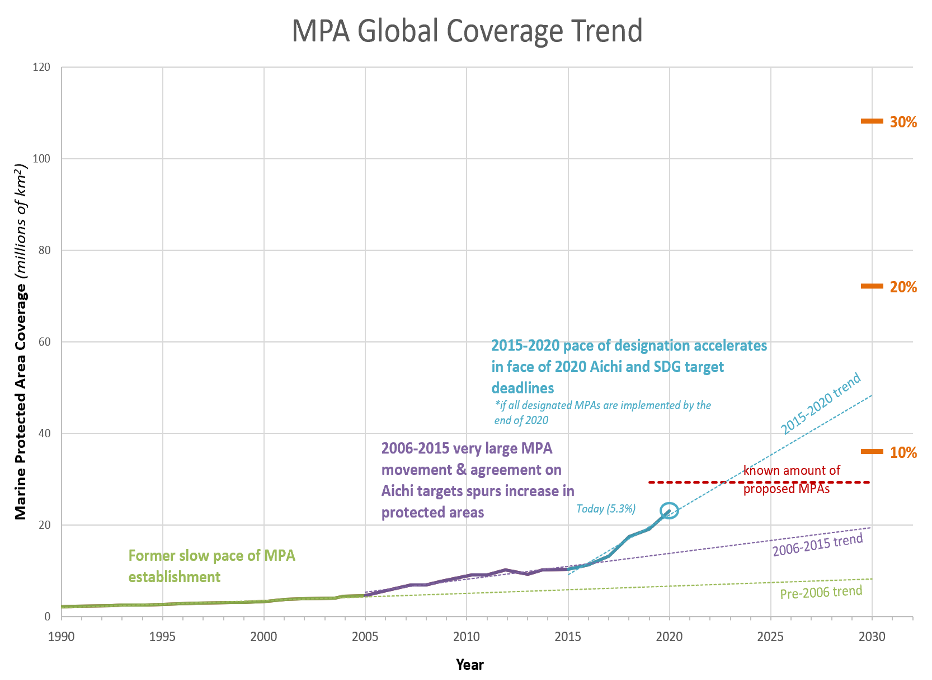
While global protected area coverage remains below the level needed to maintain healthy systems, tracking coverage over time also shows tremendous progress over the past two decades. From the 1990s to date, ocean protection has accelerated almost exponentially. In 2000, less than 1% of the global ocean was protected. By 2015 that number more than tripled to 3.5% and is on track to double within a decade. Currently, 5.3% of the global ocean is protected in implemented areas, or around 7% if we count unimplemented commitments.[8]
Despite such progress, advances towards the international target of protecting 10% of the ocean by 2020 are halting at best—reaching this goal would require the implementation of protections over millions of km2 of ocean as well as the creation of additional, large new marine protected areas by year’s end.
The international community in 2010 adopted global goals for biodiversity conservation, known as the Aichi biodiversity targets for the city in which final negotiations took place. One of those targets calls for protection of 10% of coastal and marine areas by 2020. It’s a tall order for the international community given current true protection levels remain at 5.3% counting only implemented MPAs, and just above 7% if we also count committed, but unimplemented areas. The challenge of meeting existing conservation targets, however, pales in comparison to the challenge of reaching 30% of the ocean protected by this decade (which scientists insist is the minimum needed to maintain key ocean ecosystem services): almost 120 million km2 of new MPAs globally.
Scientists and the marine conservation community have rallied around the goal of protecting 30% of the ocean by 2030[9]. This ambitious target is congruent with the urgency of the ecological crises we face. If protected area coverage in the ocean continues to increase at the same rate that it has from 2015-2020, less than 15% of the ocean would be protected by 2030. Governments need to at least double the pace of marine protection to give the ocean a fighting chance.
Meeting protection targets is further complicated by the patchwork governance across most of the ocean. Currently, there is no formal process for establishing and implementing marine protected areas within the high seas, the area beyond any one nation’s jurisdiction which encompasses around 60% of the ocean (by surface area). There is hope that may change soon, if nations can agree to final text for the High Seas Treaty which has been under negotiation at the United Nations since 2018 (and required a process of over a decade longer to get to the treaty negotiation). A study published in late March 2020 identified priority areas for conservation in the high seas, and the optimal conservation solution to protect 30% of international waters[10]. Laying the groundwork for truly international MPAs, as accomplished by this study is critical to reaching adequate levels of global marine protection.
As we grapple with navigating new targets and mustering the political will required to meet them, it is worth noting that some nations have already displayed extraordinary leadership on ocean conservation. Chile in the past decade has designated 45% of its EEZ in protected areas—while much of that remains unimplemented, it’s a noteworthy commitment.
Small island nations, often resource-strapped, have led the charge to advance global ocean conservation. This year, Palau implemented its Palau National Marine Sanctuary, covering 80% of its exclusive economic zone (EEZ) in a highly protected reserve that prohibits industrial fishing. The Seychelles this year finalized a plan that sets aside 15% of its waters as no-take (fully protected) reserves and another 15% under some form of protection, nominally meeting the 30% protection target within its national waters. Niue, an island that barely covers 260 km and has a population of just over 1,600 has just passed regulations for an MPA covering 40% of its ocean jurisdiction, making it one of the largest MPAs on the planet[11]. There’s no reason larger and wealthier nations can’t follow suit with determined leadership.
Indeed, bold and determined leadership from all nations is the minimum needed to secure a livable planet for generations to come. We’ve made tremendous progress over the past 15 years in advancing marine conservation. Yet the future of the ocean still depends on leaders dramatically accelerating conservation. Protecting 30% of the ocean by 2030 requires bold and principled leadership. As Sir David Attenborough has noted, the next ten years will impact thousands of years to come. The survival of marine ecosystems, and our own, is at stake.
Figure 1. Global trend of marine protected area (MPA) coverage, as a percentage of global ocean surface area. Atlas of Marine Protection, Marine Conservation Institute, 2020, www.mpatlas.org/.
[2] IPBES(2019): Global assessment report on biodiversity and ecosystem services of the Intergovernmental Science-Policy Platform on Biodiversity and Ecosystem Services. E. S. Brondizio, J. Settele, S.
[4] Myers, R., Worm, B. Rapid worldwide depletion of predatory fish communities. Nature423, 280–283 (2003).
[5] Duarte, C. M. et al. Rebuilding marine life. Nature580, 39–51 (2020).
[6] O’Leary, B.C. et al. Effective Coverage Targets for Ocean Protection. Conservation Letters, 9: 398-404. (2016)
[7] IUCN (2016). “WCC-2016-Res-050-EN” in IUCN Resolutions, Recommendations and other Decisions. 118-119
[8] Atlas of Marine Protection. MPAtlas.org, Marine Conservation Institute, 2020, www.mpatlas.org/.
[9] IUCN (2016). “WCC-2016-Res-050-EN” in IUCN Resolutions, Recommendations and other Decisions. 118-119
[10] Visalli, M. et al, Data-driven approach for highlighting priority areas for protection in marine areas beyond national jurisdiction. Marine Policy, 2020
Featured Picture: A Dumbo octopus (Grimpoteuthis sp.) swimming in the Gulf of Mexico. Photo credit: NOAA Office of Ocean Exploration and Research.
Today, we release the first in a series of short videos and multi-media stories about a unique place in U.S. oceans — huge underwater mountains, called seamounts. Rising from the deep, dark seafloor several thousands of feet below the ocean’s surface off the coast of California are dozens of seamounts.
Learn about what seamount are, narrated by Peter Coyote. Be sure to stay tuned as we have some amazing seamount updates coming your way!
Like the Sierra and Rocky mountains, these underwater mountains collect a spectacular array of wildlife –colorful sponges, corals, and weird fish–on their slopes. In the shallower waters above the California seamounts, predators including tunas, seabirds, and whales feed on abundant forage fish and plankton that grow fast on nutrients brought up by deep currents colliding with the seamounts.
As the ocean warms, the California seamounts are becoming climate refuges for ocean life, but like most refuges, the seamounts need protection for life to thrive. According to recent polls, the vast majority of Americans (over 90%) support strong conservation measures like establishing no-fishing or no-extraction marine protected areas in the ocean to restore and preserve special marine life, especially given climate change. We hope you will too, particularly after you see our exciting videos and engaging stories about some of America’s last, best ocean places: the California Seamounts.
P.S. Why not join our efforts to protect the California Seamounts forever and take our Seamountaineer Pledge asking decision makers for better protection of these areas?
[Glen Ellen, CA] Last Friday President Trump proclaimed June as National Ocean Month, saying that, “… we reaffirm our commitment to responsible stewardship of our ocean resources…..and ensuring that the natural beauty and wonder of the oceans are preserved and maintained for future generations.” This Friday, just before World Oceans Day on Monday, President Trump made a mockery of that proclamation by removing the only real protection that matters –- a gradual phase out of all industrial fishing in monument waters.. Without protection from industrial fishing, bottom trawling, crabbing and other extraction, the New England canyons and seamounts monument becomes nothing more than a paper park.
Marine Conservation Institute specializes in identifying, advocating for, and monitoring the health of marine protected areas around the world. Our founder, Dr. Elliott Norse, first identified the Northeast Canyons and Seamounts as worthy of more research and protection in the mid-1990’s. Many organizations worked with the Obama administration and all stakeholders to bring about the protection of the awe inspiring marine mammals, delicate deep-sea corals and sponges, and other marine life in this area.
As the first and only marine monument in the Atlantic Ocean, the Northeast Canyons and Seamounts was carefully selected for its special biological value and representativeness. Provisions were made for the slow phase out of industrial activity there over a seven year period, giving the small crab and lobster fishery time and opportunity to utilize other areas.
According to our Atlas of Marine Protection (www.MPAtlas.org) the marine monument is 5,000 square miles, representing a small sliver, just a few percent, of New England waters.
If we cannot actively conserve unique places off of America’s east coast for future generations, what kind of stewards of the natural world are we? Why can’t we preserve a few places in our oceans from extraction and leave them alone for spectacular and awe inspiring marine life to survive and grow there. In a fit of irony and hypocrisy, why must our President take this action just two days before the world celebrates its oceans on World Oceans Day?
*****
Marine Conservation Institute, founded in 1996, works in the U.S. and globally to seek strong protection for 30% of the ocean by 2030—for us and future generations. Our focus on protecting the ocean’s most important places follows several lines of work: identifying and advocating for strong marine protected areas; improving laws and other tools to better conserve marine biodiversity; catalyzing effective conservation by recognizing and elevating the best marine protected areas as Blue Parks; and accurately reporting on conservation efforts with our Atlas of Marine Protection (MPAtlas.org).
About Marine Conservation Institute
from On the Tide https://ift.tt/30cR8hf https://ift.tt/eA8V8J
For the 50th anniversary of Earth Day, we’re celebrating our blue planet through a contest that highlights people’s connections to, and experiences of, the ocean, the blue heart of our planet. Marine Conservation Institute invites you to enter our Ocean Photo Contest to celebrate our deep connection to our blue planet!
When Earth Day began in 1970, it was the culmination of an environmental movement that began decades before, inspired by the prescient writings of a marine biologist who saw ecosystems in decline all around her: Rachel Carson. The first images of Earth from space highlighted how fragile the balance of life is on our planet. Seeing our home planet as a delicate blue pearl drifting in the emptiness of space emphasized two key realities: that the planet we call Earth is really mostly Ocean (evident in the savoy blue color of Earth photographed from space), and that ours is a fragile home that necessitates better stewardship.
Arthur C. Clarke wrote: “How inappropriate to call this planet Earth, when clearly it is Ocean.” We couldn’t agree more, hence our focus on the ocean this Earth Day. Environmentalist James E. Loveluck, in 1979 added: “Nearly three-quarters of the Earth’s surface is sea, which is why those magnificent photographs taken from space show our planet as a sapphire blue globe, flecked with soft wisps of cloud and capped by brilliant white fields of polar ice.”
The old adage that a picture is worth a thousand words encapsulates the importance of early pictures of Earth from space to awakening an environmental movement half a century ago. The importance of those images of a “sapphire blue globe” inspired us to initiate our Ocean Photo Contest, to emphasize our planet’s living ocean. The ocean holds more than 95% of all livable space on Earth, and is the defining factor driving the composition of our atmosphere, the mild climate variations we have, and much more. Earth Day is at its essence a celebration of our ocean planet, the only planet that we know dominated by a watery world that both hosts unique life and makes life possible outside of it.
To participate, send us a picture taken by you, that includes the ocean in part of all of the frame (underwater images count!), along with a caption that describes the story behind the picture and the connection you felt to the ocean the moment you took it to enter to win! We’ll have prizes for the top three winners of our Ocean Photo Contest: A $100 Sand Cloud gift card for the winner, a $50 Sand Cloud gift card for the runner-up, and a Sand Cloud water bottle for third place.
We hope finding an image that captures your connection to the ocean inspires you, and our community who will vote on submitted images ahead of World Ocean Day, June 8th. These pictures can become powerful drivers of awareness and action to protect our ocean, fitting into a tradition where stunning photography catalyzes action at scale. Can anyone forget the 1968 photograph of Earth rising above the moon’s surface taken by the Apollo 8 astronauts?
from On the Tide https://ift.tt/34TADai https://ift.tt/2x2s3cM
By Alyssa Tylor, Marine Conservation Institute Blue Parks Intern.
Do you need some positive news? We realize your primary focus these days is the health and safety of yourself and your loved ones in the midst of the COVID-19 pandemic, and our goal is not to diminish those concerns. But if a little ocean optimism could boost your spirits, please read on to meet the 2020 Blue Park Award nominees.
Blue Park Awards are given to exemplary marine protected areas (MPAs) whose biodiversity and management have been evaluated using our science-based criteria. They are the MPAs that are in the right places, with the right rules, and the right management to effectively safeguard marine wildlife. We are thrilled to announce 4 nominees for the 2020 Blue Park Awards: Brazil’s Abrolhos Marine National Park, the Netherlands’ Bonaire National Marine Park in the Caribbean, Ross Sea region Marine Protected Area in the Southern Ocean, and Mexico’s Revillagigedo Marine National Park in the Eastern Tropical Pacific.
Abrolhos Marine National Park protects some of the most biodiverse reefs in the South Atlantic Ocean. These reefs include high levels of endemism with about 25% of fish and 30% of scleratin corals reported as endemic. The area is also an important breeding ground for southern right whales (Eubalaena australis) and humpback whales (Megaptera novaeangliae).
Bonaire National Marine Park protects healthy coral reefs, some of the highest fish counts in the Caribbean Sea, mangrove and seagrass ecosystems, and important nursery grounds for queen conch.
Credit: NOAA
The Ross Sea region MPA is the largest MPA in the world, covering 2,090,027 km2 of the Southern Ocean. It is the last remaining, near-pristine open-ocean and continental shelf ecosystem on Earth, and it protects numerous endemic species and half of the Antarctic orca population.
Credit: Mexican Government
Revillagigedo National Marine Park, located at the convergence of major ocean currents off the coast of Mexico’s Baja peninsula, is a highly productive area that successfully supports an incredibly biodiverse ecosystem of corals, fish, 28 shark species, turtles, giant manta rays, and humpback whales.
These nominees have demonstrated evidence of meeting these criteria, but we need your help to complete this stage of the evaluation. We have posted our evaluation reports for each of the nominees for you to review and comment forms you can use to submit your feedback on the 2020 nominees web page. Particularly if you have experience with any of these nominees, we would love your input! The public comment period will remain open until 6 May 2020 – please help us evaluate the nominees today! Additionally, we are always looking for new Blue Park nominations, so if you know an MPA that should receive a Blue Park Award, tell us about it!
After the 2020 Blue Park Awards are announced at the Our Oceans Conference, they will join an international network of outstanding Blue Parks, uniting the global oceans and the people who care about them. In stressful times, Blue Parks continue to provide ocean optimism. You can learn more about Blue Parks by visiting the website: https://blueparks.org/.
We wish you health and hope!
from On the Tide https://ift.tt/2zkQiDQ https://ift.tt/2XSeAPK
On March 26th, President Danny Faure of the Republic of Seychelles formalized a marine spatial plan for the entire exclusive economic zone (EEZ) of the Seychelles, touting “the legal designation of one-third of [the Seychelles’] ocean territory, as a marine protected area.”[1] As governments work to make good on commitments to protect 10% of the ocean by 2020, and consider more ambitious targets,[2] the President’s step of protecting 30% of its ocean territory references the widely supported target that marine scientists and conservationists recommend. It’s a step to be lauded, while recognizing that what is meant by “protection,” is not fully clear.
Marine protected areas (MPAs) are most effective when they include strong prohibitions on all extractive activity, like fishing, mining, and oil drilling[3]—what scientists and MPA managers call “no-take” MPAs. These no-take MPAs result in an average of 670% more fish biomass than adjacent areas without protection and 343% more than areas with weaker regulations.[4] Highly protected MPAs where no industrial extraction is permitted also result in biodiversity conservation benefits, but no-take reserves remain the most effective. The difference in regulations among MPAs matters.
The Seychelles identify 30% of its waters as now being within a marine protected area, and half of that is fully no-take.[5] The Seychelles’ fully no-take zone (Zone 1 in its marine spatial plan) is something to celebrate—few countries have fully protected as much of their marine jurisdiction as the Seychelles has. Fifteen percent of the Seychelles’ EEZ is an area the size of the U.K! The corals, fishes, seabirds and marine mammals in that area are now safe from fishing and other destructive activities!
The other 15% of the Seychelles’ EEZ is in a “medium biodiversity protection and sustainable use zone,” where “some level of extraction and sea bed alteration, with appropriate management”[6] are allowed. This description is vague enough that it could permit activities that pose threats to biodiversity, abundance of marine animals including fish, and the survival of some endemic species.
“Highly protected” areas which forbid industrial extraction, but might permit some subsistence or artisanal fishing can yield substantial biodiversity conservation benefits. However, it is not immediately evident whether the “extraction” and “seabed alteration” referenced in the Seychelles’ plan for Zone 2 meets the criteria for a highly protected MPA. Regulations elaborated to govern activities in this zone will determine if it contributes to truly safeguarding the Seychelles’ biodiversity or falls short.
A 2016 review of the scientific literature on area-based protection targets established that a minimum target of including 30% of each biogeographic region in the ocean within no-take reserves and/or highly protected MPAs is strongly supported by scientific literature.[7] This goal was adopted in 2016 by the IUCN with a resolution calling for 30% or more of the ocean protected within highly protected MPAs, including both no-take areas and areas that prohibit industrial extraction.
It’s clear that 15% of the Seychelles’ waters within Zone 1 (high biodiversity protection zone) should count towards the 30% science-based target for effective conservation, as it clearly will be a fully-protected reserve. Whether the other 15% in Zone 2 (medium biodiversity protection zone) will contribute to effective conservation remains to be determined. That will depend on the strength of regulations against industrial extraction within that zone.
Furthermore, legal designation is only one step towards effective conservation. Science shows that to bring back biodiversity, abundance, and maintain critical ecosystem services, MPAs need effective management: up-to-date management plans, appropriate monitoring and enforcement strategies, and the budget and staff to execute management plans and enforcement activities.
Indeed, this need for effective management, enforcement and regulations, which has at times been overlooked in marine conservation planning is the rationale for Marine Conservation Institute’s Blue Parks Program. Our Blue Parks team conducts in-depth science based assessments of conservation effectiveness for MPAs worldwide, recognizing the best examples with Blue Park Awards. The awards were envisioned as the OscarsTM or Nobel Prize of ocean protection—something that all policy makers and MPA managers can aspire to. The Blue Park Award affords credibility to MPAs that effectively protect and restore marine biodiversity.
Aldabra Atoll, one of the oldest MPAs in the Seychelles earned a platinum-level Blue Park Award in 2019, the highest recognition for MPA effectiveness. Aldabra’s award is a good omen for effective protection of the new areas designated by President Faure in his announcement last week. However, challenges remain—the Seychelles Conservation and Climate Adaptation Trust projects costs of $75-$106 per square kilometer per year to manage the Seychelles’ expanded MPA network.[8] At the upper end of that projection, the costs of enforcement might reach up to $42 million USD per year—a tall order for a small island state.
President Faure’s government has taken an important step towards securing its country’s marine biodiversity: fully protecting 200,000 km2 is a giant leap for marine conservation. But the success of the Seychelles marine conservation efforts depends on strong regulations in its Zone 2 “medium biodiversity protection zone”—another 200,000 km2 – alongside detailed management plans, effective monitoring and enforcement, and enough funding and staff to implement these plans for a vast network of MPAs.
For the ocean’s sake, the Seychelles government should be applauded for this significant step forward and should continue to lead with strong regulations in Zone 2. This along with detailed management plans, staffing and budgets for the new MPA network will result in conservation success for the Seychelles. The ocean conservation funding community should help meet President Faure’s commitment with the resources needed to truly safeguard the Seychelles’ ocean. Other nations should follow the Seychelles’ example. If a small island state can set aside 15% of its marine jurisdiction in no-take reserves and slate another 15% for additional protections, it is safe to say that many others can, and must.
[1] President Faure’s speech on Seychelles’ designation, available here: https://www.youtube.com/watch?v=eWs6tX7Ze8k
[3] Sala, E. and S. Giakoumi, “No-Take Marine Reserves Are the Most Effective Protected Areas in the Ocean,” ICES Journal of Marine Science 75, no. 3 (2017): 1166-68, https://ift.tt/3cpxSzY.
[7] O’Leary, B. Winther-Janson, M et al. “Effective coverage targets for ocean protection Running Title: Effective targets for ocean protection.” Conservation Letters, 2016; DOI: 10.1111/conl.12247
Featured Picture: A host of squat lobsters and brittle stars adorn a large pair of Paramuricea corals at a depth of 3,200 feet in the Gulf of Mexico. Photo courtesy of Ocean Exploration Trust and ECOGIG.
By Samuel Georgian, Marine Biogeographer at Marine Conservation Institute
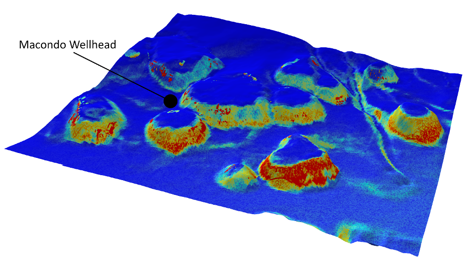
Given the depth of the spill, it should not be surprising that some of the most serious ecological damage stemming from the spill occurred in deep-sea habitats. Beautiful, expansive deep-water coral communities as far away as 14 miles from the wellhead were found to have been damaged by the oil as well as the chemical dispersants used during the resulting cleanup. Corals in the genus Paramuricea, among the more commonly found corals in the region, were found to be severely affected following the spill. Colonies in the region surrounding the wellhead exhibited typical signs of stress including excess mucus production, tissue loss, and death. Laboratory experiments later confirmed that oil and dispersants are toxic to Paramuricea colonies. How many Paramuricea colonies were affected by the spill? We will likely never truly know. Some corals have recovered since the spill, making it difficult to assess the full extent of the initial damage. A bigger obstacle, however, is simply the huge area that was covered in oil and dispersants – an area far too large to directly survey due to the prohibitive cost and difficulties associated with deep-sea research expeditions.
Thankfully, researchers can use models to fill in our knowledge gaps using the relatively small amount of information that is already known about these remote deep-water ecosystems. Along with coauthors from Temple University, the Bureau of Ocean Energy Management, and Penn State University, we recently authored a publication in the Journal of Biogeography detailing our effort to model the population distribution of Paramuricea in the area surrounding the Deepwater Horizon spill. By combining environmental data with locations that we already know Paramuricea is found, habitat suitability models can predict where additional colonies might be located in unexplored areas.
The remotely operated vehicle (ROV) Hercules monitors cold-water coral communities affected by the Deepwater Horizon oil spill in the Gulf of Mexico. Photo courtesy of Ocean Exploration Trust and ECOGIG.
We first constructed a set of environmental data from the northern Gulf of Mexico, including a novel high resolution bathymetric map pieced together from three dimensional seismic surveys, temperature, salinity, food availability, shape of the seafloor, and substrate type. These factors were selected because previous modeling, field, and experimental work suggests that they are critical for the success of deep-sea corals. Most corals exhibit fairly narrow temperature and salinity requirements, and frequently grow in areas with high food availability since they do not contain the symbiotic algae that provide shallow-water corals with the bulk of their energy requirements. The shape of the seafloor may seem like an unusual factor for dictating coral growth. Corals typically prefer to grow on elevated features like mounds or boulders because these features experience faster currents, bringing more prey items past the corals while also transporting larvae and preventing sedimentation. Finally, almost all corals require a hard substrate to attach to, often making substrate type the most important factor in models.
Habitat suitability map showing the predicted distribution of Paramuricea corals in the vicinity of the Deepwater Horizon oil spill. Warmer colors indicate more suitable habitat, mostly clustered on the steep slopes of mounds where elevated currents increase food and larval supply.
These environmental data were combined with the previously known distribution of Paramuricea to generate predictive maps of where we expect to find more Paramuricea colonies, even in areas that have never been explored. The results have significant implications for the magnitude of damage caused by the Deepwater Horizon oil spill. In the areas surrounding the wellhead where previous field expeditions found clear evidence of damage to corals, the model predicted that more than 4,000 Paramuricea colonies should exist, vastly outweighing the few sites that have currently been discovered. Coupled with the fact that Paramuricea corals are extremely slow growing and long lived (>600 years), these results indicate that the Gulf of Mexico population is unlikely to recover quickly from the massive damage incurred by the Deepwater Horizon oil spill.
Given the incredible fragility of these habitats and the low likelihood of recovery for deep-sea corals, these findings should be applied by conservationists and managers to design a strategic network of reserves, in which no exploitation is allowed. Such a strategy can be used to mitigate future catastrophes and help maintain the incredible diversity of the Gulf of Mexico.
from On the Tide https://ift.tt/2V9Qoqr https://ift.tt/34FZhv0
Featured Picture: Life is both weird and beautiful in the deep ocean. Here, a Schaefer’s Anglerfish (Sladenia shaefersi) uses modified fins to walk along the seafloor in search of prey. Photo courtesy of NOAA.
By Samuel Georgian, Marine Biogeographer at Marine Conservation Institute
The deep sea is so remote that many people are completely unaware of the incredible diversity – and absolute strangeness – of the creatures inhabiting these deep waters. That’s right, life starts to get a little weird as you venture below 200 meters. From sharks straight out of nightmares, the always-terrifying giant isopod, and the aptly named blobfish, many deep-sea organisms appeared to have evolved on another planet. There’s probably a reason for that – the deep-sea is an extremely harsh environment – devoid of sunlight, under extreme pressure, and very food limited – causing organisms to evolve quite differently than in shallow water or terrestrial environments. Fortunately for us, this weirdness has resulted in the creation of natural chemical compounds that have significantly advanced medical and scientific research.
Obtaining useful chemical compounds from nature is nothing new – a whopping 37% of pharmaceutical sales are drugs that were derived from plant or microbial life, with 10,000 compounds isolated from marine environments alone. Aspirin may sound like a futuristic wonder drug, after all it relieves pain, prevents heart attacks, and may even reduce cancer rates. But it wasn’t created in a lab, it’s derived from the salicylic acid found in certain shrubs and tree bark – gifting humans relief all the way back to the ancient Greeks. Natural compounds have found important uses outside of medicine as well. The key enzyme that allows us to replicate DNA in the lab (the prerequisite for an incredibly long list of applications ranging from forensics, paternity testing, modern agriculture, and taxonomic identification) stems from the discovery of an oddly heat-resistant bacteria from a hot spring in Yellowstone National Park.
A willow tree’s bark contains salicylic acid – a precursor to modern-day Aspirin. Photo courtesy of Francisco Delgado.
The majority of known ‘useful’ compounds come from terrestrial or shallow-water marine environments – simply because that is where we have sampled the most organisms. However, in the more limited sampling that has been conducted in the deep ocean, there are already a number of examples of deep-sea chemicals that are already being used by humans. A deep-sea sediment core collected in the vast North Pacific Ocean had some unusual and unidentifiable bacteria, which in turn were found to create some unusual chemicals that bolster our immune response to both herpes and HIV. A sponge collected off the coast of the Bahamas was found to contain alkaloids (morphine is another example of a naturally-derived alkaloid) that may extend the lifespan of people diagnosed with leukemia, lung cancer, colon cancer, and melanomas. Other deep-sea organisms have been found to contain chemicals that are being developed as an anti-inflammatory in skin cream, to treat a myriad of tumors, to treat nerve damage, and as antifungal agents. Reminiscent of the Yellowstone enzyme that first made DNA replication possible in the lab, a chemical from a deep-sea Archaea from hydrothermal vents is currently being used as a heat-resistant but much less error prone DNA replication tool. These advances in DNA replication capabilities are a key component of rapid viral testing, including the tests currently being developed for the COVID-19 virus that is sweeping the planet.
Sulfide chimneys at a hydrothermal vent at the Urashima vent site. Vent sites like this are where Thermococcus litoralis grows, a sulfur-eating Archaea that has allowed for lab-DNA replication with a very low error rate. Photo courtesy of NOAA.
Given the vast area of our oceans that have yet to be explored, let alone sampled, it is likely that there is a treasure trove of chemical compounds waiting to be uncovered in some of the strange creatures that call deep waters home. Unfortunately, deep-sea ecosystems are under a barrage of threats ranging from climate change, overfishing, pollution, and resource extraction. So while the deep sea can be weird to the point of seeming a little scary, perhaps the scarier thought is that we might destroy this trove before we’ve fully explored the treasures that lie within.
It’s easy to dismiss the deep sea. It’s far away, weird, and has less obvious ties to humans. However, as scientists study more deep-sea habitats, we continue to not only uncover life-altering chemical compounds, but we’ve also learned that the deep-sea provides a wide array of critical ecological services. Deep-sea coral reefs provide key nursery habitats that thousands of other species rely on, including commercially important fish and invertebrates. Recent research shows that deep-sea ecosystems also play critical roles in the ocean’s carbon and nutrient budgets, recycling nutrients back into other marine ecosystems while providing very long-term sequestration of carbon that would otherwise contribute to global climate change and ocean acidification. Speaking of climate change, scientists believe that deep-sea habitats may serve as climate refugia where corals and other marine organisms can survive as our oceans warm and acidify. The deep-sea also provides important scientific and educational opportunities, as well as aesthetic beauty (weirdness and all!), not just for us, but for generations to come.
So who needs the deep sea? We all do.
from On the Tide https://ift.tt/3bUx6ef https://ift.tt/2V7b0yn
Like you, many of our staff are sheltering at home to prevent the spread of COVID-19. We sincerely hope that you and your loved ones stay healthy!
While we all deal with these very challenging times, we asked our staff to recommend ocean related activities that everyone in the house can participate in. Whether you are parents looking for something to do with the kids, or just an interested person looking for something fun and educational, you are sure to find something on this list! Here is a list of books, videos and things you can participate in while the shelter order is in place:
For students looking for more fun ideas to engage their scientific curiosity follow the Twitter hashtag #SchoolsOutScience
Finally, Netflix has created a directory of more than 150 educational shows. Click here to see the list. They also offer this tip: Create a separate profile on Netflix. Name it “School” and add ONLY educational materials to this profile. Then when you need to keep the kids busy, allow them to watch only shows you have added to this account. It works great and keeps the kids from getting sidetracked by the show they’re currently binge-watching.
Stay safe and healthy, our thoughts are with you during this time. If you have other suggestions for ocean related activities share them with us on twitter @savingoceans!
from On the Tide https://ift.tt/33vk0B7 https://ift.tt/eA8V8J
Featured Picture: Malpelo Fauna and Flora Sanctuary. Photo courtesy of Ramón Pulido.
By Sebastian Nicholls, Blue Parks Ambassador.
Surrounded by mangroves that grow on low-lying islands and the mainland coast, the Port of Buenaventura bustles with activity—it’s a gateway to that largest of oceans, the Pacific, and the diverse wildlife that calls the Colombian Pacific home.
Offshore, far beyond the horizon, a mountain range rises from the ocean’s depths to hundreds of feet above the surface—creating the island of Malpelo and in its surroundings, a unique habitat critical to marine biodiversity in the Eastern Tropical Pacific. Those habitats surrounding Malpelo have been protected since 1996, and conservation efforts have paid off.
I boarded a converted buoy tender from the North Sea to head to Malpelo Island in August 2019 as part of a Mission Blue expedition to tag highly migratory species and observe wildlife in this unique marine environment. Once we crossed the 300 mile expanse of blue between the mainland and Malpelo Island I was blown away by the abundance of birds, sharks, fish and healthy coral around the island.
The Malpelo Fauna and Flora Sanctuary, a marine protected area covering 27,096 square kilometers, received a Blue Park Award from Marine Conservation Institute in 2017 for outstanding conservation effectiveness. Rigorous monitoring over 19 years shows that populations of reef fish have grown remarkably since its conservation measures came into effect, a huge win for ocean wildlife. The dividends are visibly appreciable.
Once we drop into the water, diving at a site called Arrecife (Spanish for “reef”) we can see the dividends of rigorous conservation management work. As we drift over the rocky reefs and corals, suddenly a flurry of activity begins – schools of leather bass patrol each nook and cranny for a bite. Moray eels swim free, following the hunt to pick up the scraps and laggards that the leather bass miss. Trevally and jacks look for their breakfast. Underwater, Malpelo is an explosion of life.
Photo courtesy of Marcela Ochoa.
This amazing biodiversity is Colombia’s greatest treasure. Colombia is an ocean country– its marine jurisdiction represents 40% of its total surface extension. However, like many countries, Colombia is behind on protecting its ocean. Sustainable Development Goal 14 includes a target for protecting 10% of marine areas by 2020. Today, 12.9% of Colombia’s marine jurisdiction is designated to be protected, but only 4.1% is highly protected, in MPAs where fishing is very restricted or forbidden (MPAtlas).
The Malpelo Fauna and Flora Sanctuary Blue Park represents the vast majority of Colombia’s no-take marine area, where no fishing is allowed. Highly protected and fully protected marine areas reliably result in more abundant populations when they are also well managed and well enforced. To date, the monitoring data from Malpelo indicate that regulations are paying dividends for marine life.
Those abundant schools of leather bass, Pacific barracuda, snappers and moray eels that accompanied me on my first dive in Malpelo reflect the MPA’s effectiveness, a trait more rare than it should be among MPAs. Effective management and enforcement often take time and lag behind the creation of protected areas on paper. Marine Conservation Institute’s Blue Parks program emerged from a recognition that effective conservation requires more than MPA coverage targets – it also requires MPA quality targets. The Blue Park Award criteria set a quality standard for MPAs that includes biologically significant placement and design, strong regulations, effective management and high compliance.
Photo courtesy of Kip Evans, Mission Blue.
The Malpelo Fauna and Flora Sanctuary, along with 15 other Blue Parks awarded to date, provide examples of what effective MPAs can achieve. At Malpelo, a cast of conservation partners including the Malpelo Foundation, National Parks Colombia, the Malpelo Action Fund, Biodiversity Conservation Colombia, Migramar, and Conservation International, work together to make sure the sharks and fish are safe; but challenges remain.
Despite the protections granted by the Colombian government, not all marine life there is safe. “The biggest threat to the protected area,” says Sandra Bessudo, founder of the Malpelo Foundation and Hope Spot Champion for Malpelo, “is illegal fishing.”
“It’s done mostly by vessels from neighboring countries… where they come in and enter the protected area [illegally], to capture snappers, groupers, sharks; all this biodiversity”
It’s a difficult threat to counteract. By boat, it takes 36 hours to get from mainland Colombia to Malpelo. Even with reports of illegal fishing, it’s difficult to capture poachers.
Monthly expeditions led by the Malpelo Foundation serve two critical purposes – to study animal populations in Malpelo and also to keep a lookout for illegal fishing.
Sandra Bessudo, who worked with Marine Conservation Institute through Malpelo’s Blue Park evaluation, noted an ominous sign. “We’ve seen reef fishes increase in abundance, diversity, and size of individuals, but hammerheads and silky sharks are in decline.” Hammerhead sharks were recently reclassified by the IUCN Red List as Critically Endangered. They often travel beyond the boundaries of protected areas, so a strong network of protected areas with ecosystem connectivity is crucial to ensure sharks’ survival.
Photo courtesy of Santiago Estrada.
The Blue Park Awards are a means to an end: a way to encourage quality improvements of MPAs to ultimately protect 30% of each ocean ecosystem within a network of Blue Parks. In the Eastern Tropical Pacific, that vision has come closer to reality with two additional Blue Parks awarded after Malpelo in 2017. Cocos Island and the Galapagos Marine Reserve both earned Blue Park Awards last year and protect not just many of the same species but the same individuals within their boundaries.
There are sharks – silky, hammerhead, whale sharks – that have been tagged and observed moving from one Blue Park in the region to another. These highly migratory species will only survive with strong protections across their critical habitats. Blue Parks in the Eastern Tropical Pacific, starting with Malpelo, form a network of well-protected and effectively managed marine protected areas that give endangered wildlife a fighting chance. Our work aims to expand this network to a global scale.
If you would like to learn more about our Blue Parks, visit us at www.blueparks.org
from On the Tide https://ift.tt/2xvqZhr https://ift.tt/2W0YQcl
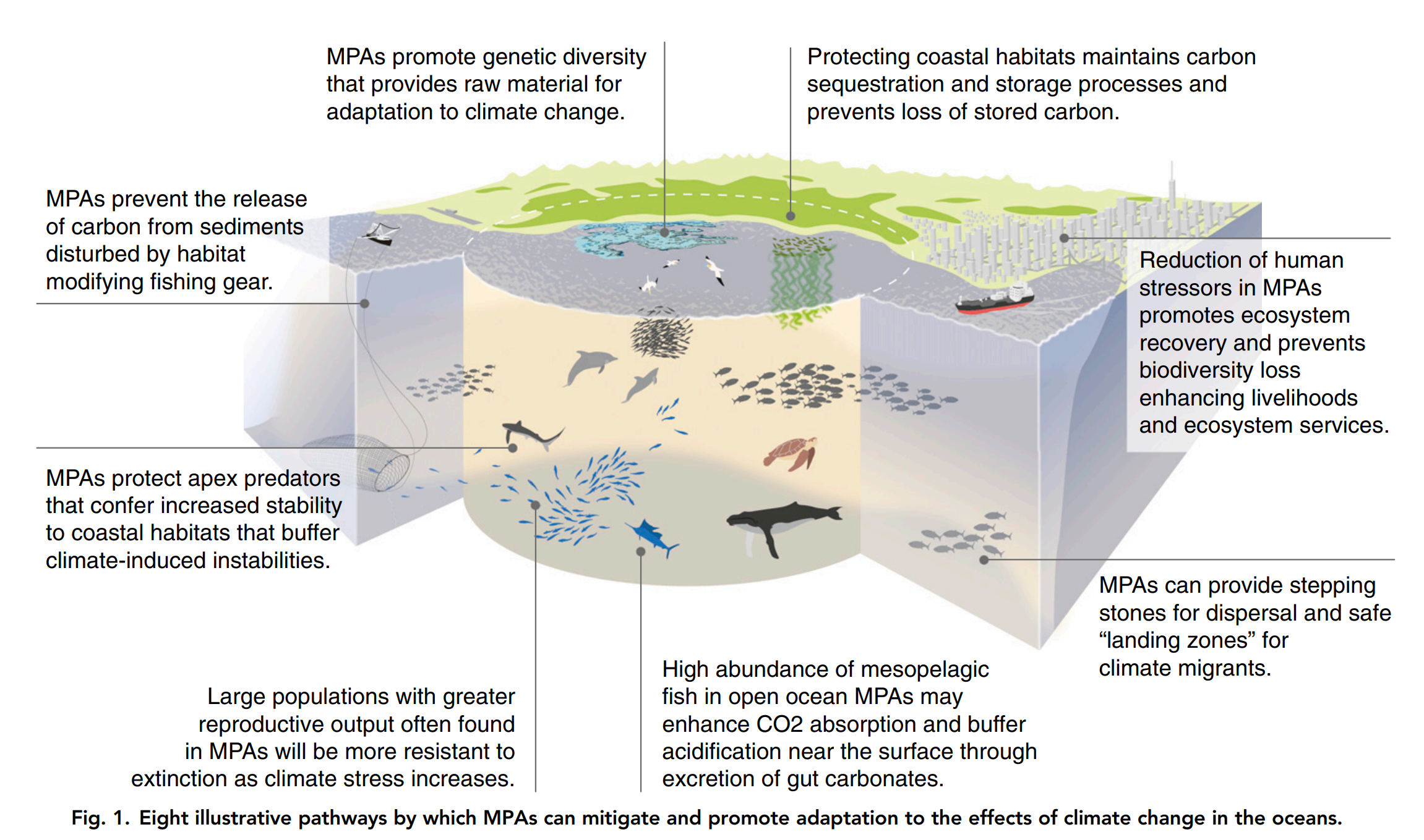
Recently, Amazon CEO and the world’s wealthiest person, Jeff Bezos, pledged $10 billion to fight climate change, which he referred to as “the biggest threat to our planet,” via the creation of the Bezos Earth Fund. The vast opportunities created by such large philanthropic initiatives prompt thoughtful deliberation about the necessary actions to minimize and mitigate climate impacts. We often focus on mechanisms that directly reduce fossil fuel consumption, such as using less energy and driving electric cars. There is no question that a significant reduction in global greenhouse gas emissions is required to minimize climate impacts, and the investment in and adoption of renewable energies is vital. However, as this change won’t happen overnight, it is also critical to protect the health of Earth’s “immune system” – the ocean. The ocean and climate are inextricably linked. Oceans absorb nearly one-third of carbon dioxide emissions and approximately 90% of the excess heat retained by greenhouse gases (GHG). As a result, marine ecosystems and species are facing critical stresses and threats due to increased emissions from human activities, including sea-level rise, acidification, deoxygenation, increased intensity and frequency of severe weather events, and shifts in species distribution and habitat suitability. While the ocean bears the brunt of many climate impacts, ocean health is also a critical part of the solution. Protecting healthy, functioning marine ecosystems is a key part of resilience. Strong ocean protections build and maintain ocean health, allowing for greater resistance to and quicker recovery from ecological as well as climate impacts. Marine protected areas (MPAs), although not immune to climate impacts, provide areas of reduced stress on ecosystems and species, allowing for the restoration and maintenance of natural processes that mitigate climate impacts and provide ecosystem services. One example of positive climate impacts from ocean protection comes from great whales. Recently, it was estimated that rebuilding whale populations to pre-exploitation levels would improve productivity in surface waters, dramatically increasing carbon capturing phyto-plankton through nutrient cycling (i.e., whale poop). As another example, with the potential for more severe weather events in a changing climate, healthy coral reefs reduce the power of waves and serve as natural barriers that protect coastal communities from storm impacts and wave damage. Many MPAs also protect important coastal wetlands that sequester carbon, maintain pH, and serve as ecological refugia for calcifying organisms. Minimizing human impacts, such as habitat destruction and overfishing, also increases resilience and safeguards ecosystem services upon which people rely, such as fisheries and natural water filtration, and prevent carbon sequestered in benthic sediments from being released due to disturbance.
As seen in: Roberts, C.M. et al. (2017) Marine reserves can mitigate and promote adaptation to climate change. PNAS 114(24): 6167-6175.
In addition, MPAs will also help protect and maintain biodiversity in the face of climate change. Increased population size and genetic diversity from limited extraction and habitat destruction increases species resilience and adaptability to climate impacts. With warming water temperatures, many mobile species may shift their distributions toward the poles, and migratory species may alter the location and timing of their movements. Ecosystems protected from the damaging impacts of fishing gear and other human activities will maintain suitable habitats for displaced organisms and create a network of healthy ocean areas for migratory connectivity. Collectively, MPAs are one of many useful and necessary tools for climate mitigation, resilience, and adaptation. To create sufficient and effective protected areas and maintain healthy ocean ecosystems, political and financial mechanisms will be necessary to boost resources and support for the implementation and active management of fully and highly protected areas. At Marine Conservation Institute, our Blue Parks initiative works to recognize outstanding marine protected areas, incentivize new efforts, and unite MPA communities worldwide. It’s our goal to create an urgently-needed worldwide system to ensure future diversity and abundance of marine life in healthy ocean ecosystems. Become an Ocean Guardian or donate to support our work to enhance the ocean’s climate change resiliency.
from On the Tide https://ift.tt/2TrmhK4 https://ift.tt/2TpBYBm
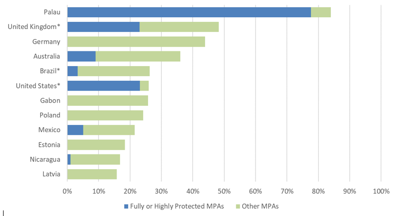
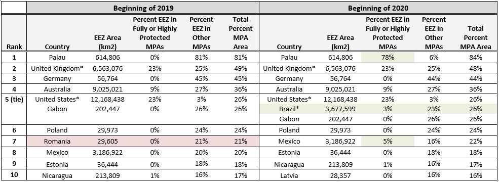
Marine protected areas (MPAs) are a vital tool for conserving marine biodiversity and ocean health in the face of human-caused threats, such as habitat destruction, overfishing, and climate change. They provide a wide range of benefits, such as increasing biodiversity and biomass, protecting endangered species, recovering overfished populations and sequestering carbon, justifying their inclusion as part of several international conservation goals. Direct measurements of biodiversity are difficult to obtain and protected area coverage is used by nations as an indicator of conservation. With the 2020 deadlines for the Convention on Biological Diversity Aichi Target 11 and UN Sustainable Development Goal 14 upon us, many involved and interested parties are eager to learn where we currently stand, what progress has been made, and what must still be done to reach adequate levels of marine protection across the globe. While MPAtlas.org reports that 5.3% of global marine area is currently protected, some countries have far exceeded the 10% goal within their own coastal waters and exclusive economic zones (EEZs). As of the beginning of 2020, the 10 countries with coastal and ocean domains greater than 10,000km and the largest percent MPA coverage are as follows: Palau, United Kingdom, Germany, Australia, Brazil, United States, Gabon, Poland, Mexico, Estonia, Nicaragua, and Latvia (Figure 1).
Figure 1. Top 10 countries by percent marine protected area (MPA) coverage in their exclusive economic zones (EEZ). Asterisks (*) denote countries in which the majority of MPAs are in offshore territories.
Palau has set the bar high, not only for total MPA coverage but also area of fully protected areas. Fully and highly protected areas are vital to effective marine protection, as they are significantly more likely to produce positive conservation benefits than areas that allow extraction, such as fishing and mining. Palau National Marine Sanctuary, which went into effect on January 1st, now protects 80% of Palau’s waters from all extractive activities, creating one of the largest fully protected areas in the world. While it has been reported that the loss of commercial tuna fishing has increased pressure on reef fish, this short-term impact could be mitigated as the market stabilizes and creates a domestic supply of tuna or other sustainable options to meet demand. Such a shift takes time and demonstrates the fragile balance between short-term human needs and long-term conservation. MPAs are a key part of ensuring long-term sustainable use while protecting vibrant biodiversity and ecosystems for the future.
Brazil is the only newcomer to the top 10 list, as it substantially increased its protected area coverage over the past year, while many other countries remained the same (Table 1). Two new, large protected areas located around the Archipelagos of Sao Pedro and Sao Paulo, and Trinidade and Martim Vaz, increased Brazil coverage from less than 2% to nearly 26%. Within each protected area, a fully protected Natural Monument is surrounded by a sustainable use zone.
It is important to note that these new MPAs in Brazil, as well as the majority of MPA coverage in the United Kingdom and United States, are located in offshore territories, rather than the nearshore waters of the country’s mainland. If only considering MPAs in each country’s mainland areas, the United Kingdom and United States would have 2% and less than 1% coverage, respectively. Many offshore MPAs surround remote, uninhabited or low population land masses, making MPAs easier to implement than in higher-use coastal areas, where often faced with local resistance from fear of negative impact on livelihoods. However, MPAs in these areas may not show the greatest increases, since higher-use areas that are overfished or degraded will likely see highest return on investment.
Table 1. Top 10 countries by percent marine protected area (MPA) coverage in their exclusive economic zones (EEZ) at the start of 2019 and 2020. Asterisks (*) denote countries in which the majority of MPAs are in offshore territories. Green highlights represent positive changes and red highlights represent negative changes in coverage over the year.
In the past year, Mexico has also implemented a new offshore MPA: Revillagigedo National Park. Previously a biosphere reserve, the waters surrounding the Revillagigedo Islands are now fully protected from fishing and other extractive industries. These relatively pristine waters will now protect over 300 fish species, 37 ray and shark species, coral gardens, and important humpback whale calving grounds.
Meanwhile, some countries MPA coverage decreased over the past year; Romania’s decreased to 5%, losing its place in the top 10. Upon assessment by the MPAtlas team, a large portion of Romanian sites lost their MPA status, since although they were self-reported as an MPA to the World Database on Protected Areas (WDPA), they do not actually meet the requirements of an MPA as defined by the IUCN. Primarily, the Delta Danube is designated as a UNESCO World Heritage Site, a Ramsar Wetland of International Importance, and a UNESCO-MAB Biosphere Reserve; however, while these honors denote inherent value, none of them include specific laws or regulations for conservation.
Overall, the leading countries in MPA coverage have remained stable or improved over the past year, with several countries continuing to expand and strengthen protections within their waters. As time passes and the urgent need for effective protection measures grows, many others will look to these countries as leaders. Therefore, although they have surpassed the 10% goal for 2020, they should continue to strive to achieve fully or highly protection levels and encourage others to do so, as well.
from On the Tide https://ift.tt/2wuipPf https://ift.tt/2VLzYoH
Featured Picture: A rockfish searches for a place to hide off the coast of Southern California. Photo courtesy of NOAA.
By Samuel Georgian, Marine Biogeographer at Marine Conservation Institute
The next time you order fish at a restaurant, pull out your phone for a second and research where it might have come from (Monterey Bay Aquarium’s Seafood Watch app may help you here). The answer may just surprise you. While many fisheries operate close to shore and in shallow waters (maybe you can even see the fishing boat from your table), as near-shore fisheries collapse, more and more operations are moving offshore and into deeper waters. Surprisingly, your dinner may have been scooped up from one of the most remote places on the planet – the top of a seamount. Seamounts are massive undersea volcanoes that support biodiverse ecosystems teeming with life in the often otherwise sparsely populated deep sea. Why fish remote places like seamounts? Seamounts often house abundant fields of deep-sea corals and sponges, which in turn create three-dimensional habitat structures that are invaluable for a wide array of fish and invertebrates, including many commercially-fished species. Fisheries often target seamounts because fish aggregate on their slopes, summits, and waters above as they use these ecosystems as key nursery, feeding, and reproductive grounds. The aptly named rockfish are commonly found in seamount habitats, and many species – including the Pacific rockfish (Sebastes alutus), the bocaccio (Sebastes paucispinis), and the yelloweye rockfish (Sebastes ruberrimus), are frequently fished in Californian waters (although you may see all of them listed on the menu as ‘red snapper’).
A school of widow rockfish swim above a colorful bank of sponges and anemones at Cordell Bank. Photo courtesy of NOAA.
Unfortunately, the latest research confirms what we already knew: bottom fishing on seamounts is incredibly destructive to the coral and sponge ecosystems that these fish rely on. In a recent paper published in Marine Policy, the authors looked for evidence that bottom-contact fisheries had on seamount habitats in the North Pacific Ocean. What they found was sad, but not surprising: barren stretches of seafloor with nothing but scars from fishing gear, coral colonies reduced to rubble, lost or abandoned fishing gear, and the notable absence of previously abundant coral species. In many cases, bottom-contact fishing involves bottom trawling, where a large weighted net is dragged along the seafloor, indiscriminately catching the targeted fish species along with unwanted bycatch including corals, sponges, and other fish. Bottom-trawling is an incredibly destructive fishing method capable of destroying entire, ancient ecosystems in one pass. While the authors of this study – like many before them – recommend that seamounts be closed to these fisheries, the vast majority of seamounts around the world do not have any meaningful protections in place. Marine Conservation Institute is currently working to protect the 60+ seamounts off the coast of California from fisheries, oil and gas development, future deep-sea mining, and climate change. Currently, only one of the seamounts offshore California’s coast is protected within federal sanctuary boundaries (Davidson Seamount in Monterey Bay National Marine Sanctuary), leaving the rest vulnerable to human pressures.
So, the next time you eat fish, take a closer look at what type of fish it is, and where it was taken from. Spare a thought for the fragile ecosystem that may have been damaged along the way.
from On the Tide https://ift.tt/2wBNnVN https://ift.tt/2PpaMk2